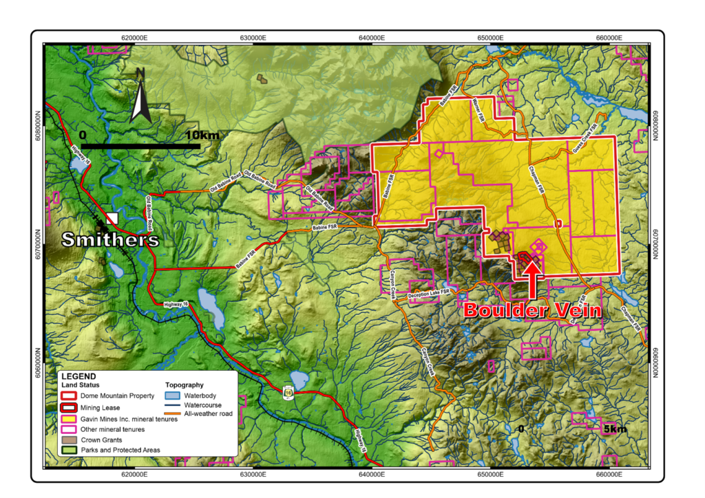
The Dome Mountain Gold Project (the “Project” or the “Property”) is an all-year road accessible project located a short 50-minute drive from Smithers, British Columbia, Canada (see further down, Figure 1). The 100%-owned titles cover an area approximately 22,000 hectares, highly fertile for both gold and porphyry mineralization.
The historical Dome Mountain Gold Mine (the “Mine” or “Dome Mountain”) is located in the southern part of the Property and has seen past portal/adit development and sporadic gold production from the Boulder Vein, which was originally discovered by Noranda in the mid 80s.
As of February 2025, the Mine is fully permitted to re-commence Gold (“Au”) production and Blue Lagoon Resources is planning to achieve this transformative milestone in mid-2025 – it is expected that first mineralized material will come out of the main Mine portal as early as July 2025.
Highlights of the Dome Mountain Gold Project and the Dome Mountain Gold Mine
- Ownership: 100% Blue Lagoon Resources, a company with absolute focus in BC, Canada.
- Property size: 21,541 ha.; 26 claims.
- BC Government Ministry of Mines and Critical Minerals recently permitted the re-opening of the underground Mine (Mine Permit 237, February 2025)
- Mining Permit provides for initially up to 55,000 tonnes mined / annum.
- Gold production to commence in Q3 2025.
- Milling agreement in place with Nicola Mining Inc., operating an existing milling and tailings facilities near Merritt, BC.
- Currently Blue Lagoon is finishing preparatory tasks and activities, including the installation of a water treatment plant, with estimated completion date in June 2025.
- Estimated recovery of 15,000 ounces of gold per year *
- Full support by Lake Babine First Nation. Strong local community support.
- Quality and experienced Mining Contractors in place; Roughstock Mining Services & Cobra Mining and Excavating Ltd.
- Environmentally-friendly waste storage inside the underground mine.
- A relatively very low Pre-production Capex is currently spent by Blue Lagoon, mainly in the Mine Water Treatment Plant and local infrastructure.
- The Property has seen more than $80 million spent since discovery by Noranda in 1985, inclusive of $30+ million by Blue Lagoon since acquisition in 2019.
- High-grade (Au, minor Ag) quartz carbonate, sulphide veins, mainly hosted by volcanoclastic rocks; being explored as an Alkali Gold System. Significant strike length.
- The principal zone of high-grade gold-silver mineralization is known as the Boulder Vein System, comprising the Boulder, Boulder East, and Argillite veins.
- Significant blue-sky exploration and development potential. Although the Property has 15 known high-grade gold veins, 90% of the claims are still underexplored.
- The veins occur within a 55-70° dipping deformation zone, averaging 10 metres or less. Only the Boulder Vein System is relatively well explored to date.
- Two new discoveries in 2021 drilling by Blue Lagoon Resources. The Chance prospect is a nearby (~500 metres) shallow-dipping structural system with associated gold+/-silver vein mineralization. The current drilling defines a 400m x 400m zone with additional strike potential. Drilling in the Federal Clearcut area intersected extensive sulfide mineralization but, so far, only minor precious metal grades.
- The historical Forks area represents another nearby (<1km) vein system with gold-silver potential.
- Airborne geophysics (magnetics, radiometrics and EM) coverage, flown in 2020 by Blue Lagoon, shows high mag contrast and anomalous conductors for follow-up work including soils, prospecting, and mapping
- Only 6 of the 15 known gold veins and two airborne magnetic targets have been tested by Blue Lagoon to date. New targets generated, apart of geophysics, by collection of 4,000+ soil samples.
- Total drilling over the Property: 596 holes (including 43 underground holes) totalling 89981.66 metres. Average depth of surface drill holes is approximately 160 metres. Blue Lagoon has drilled:
- 2020: 26 holes for 3,786 metres
- 2021: 85 holes for 22,690.79 metres
- 2022: 66 holes for 19,552.07 metres
- 2023: 10 holes for 2,908.80 metres
- In 2022, an independent Mineral Resource Estimate (“MRE”) was prepared by Arseneau Consulting Services (January 31, 2022, NI 43-101 Technical Report filed at SEDAR) over the central part of the Boulder Vein system showing:
45,000 oz Au (Measured) at 10.32 g/t;
173,000 oz Au (Indicated) at 8.15 g/t;
16,000 oz Au (Inferred) at 6.02 g/t;
Plus
250,000 oz Ag (Measured) at 57.31 g/t;
876,000 oz Ag (Indicated) at 41.19 g/t;
71,000 oz Ag (Inferred) at 26.13 g/t;
(using a 3.5g/t Au cut-off that applies to the Boulder vein system only)
- Mineralization at the Boulder vein system is still open to all directions. A number of holes have intersected the Boulder and the Argillite veins, east, west and down-dip, since the 2022 MRE. Infill drilling is planned to bring additional ounces of gold and silver into the MRE.
- Grab rock samples and drill intersections from sporadic drilling over veins and brecciated areas other than the Boulder vein, show grades up to 1,215 g/t gold (Au), and up to 1,809 g/t silver (Ag).
* Any production decision in advance of obtaining a feasibility study of mineral reserves demonstrating economic and technical viability of the project is associated with increased uncertainty and risk of failure.
Geology Notes
The Boulder Vein is a structurally controlled quartz carbonate vein system with variable sulfide composition up to and over 20% combined pyrite, sphalerite, galena and chalcopyrite. The immediate host rock is basaltic andesite of the Jurassic aged Telkwa Formation consisting of volcanic and volcanic fragmental flows and tuffs. The entire sequence lies within the Babine Range which is a northwest trending horst of folded and faulted Jurassic and Cretaceous volcanic and sedimentary rocks, known as the Hazelton Group. This is bounded to the west and east by grabens of Late Cretaceous and younger rocks. Locally the Hazelton Group rocks are intruded by rocks of the Early Cretaceous Bulkley Plutonic and the Eocene Nanika Plutonic suites.
For details on the various drilling phases of both the Boulder Vein but also other peripheral target veins and specific DDH mineralization intersections, one should refer to the corporate news releases on drilling campaigns between 2020 and 2023.
The Freegold veins are high grade gold bearing quartz carbonate veins with up to 40% sulfide content. These cut both the volcanic rocks of the Telkwa Formation and a quartz monzonite intrusion centrally located on a magnetic low within a larger circular magnetic high as defined by the 2020 airborne geophysical survey. Recent work has shown that this system of mineralization could very well be structurally controlled, carbonate hosted, base metal rich gold mineralization similar to Cowal Lake Gold deposit (NSW Australia) or Buritica in Colombia. Additional drilling into the intrusive has demonstrated porphyry-style mineralization potential with appreciable zones of molybdenum mineralization.
The 2020 heliborne airborne survey at 100-meter line spacing (Figure 6, 7) highlighted a very strong northwest trending mag signature, which shows high contrast to surrounding rocks and abundant targets for further prospecting and drilling. There is very little outcrop available along this 12-kilometer trend and prospecting and soil sampling will be used to define priority drill targets. Off sets and linear show high potential for defining structural controlled type gold targets. In addition, five high priority targets were defined as potential copper porphyry targets and are considered near drill ready.